Sundance Utah (US)
Location, Map and Directions
Video Tour of Sundance:
Virtual Tours:
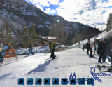
Base of Sundance
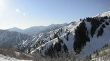
Top of Holman's Hollow
Sundance is located a reasonable 55 miles from Salt Lake City airport. Rental car or shuttle are your only transport options.
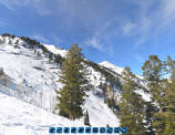
Sundance (mountain base):
-
Utah United StatesLatitude: 40.391416
Longitude: -111.578409
Resorts Nearby:
- Park City/Canyons UT (35 miles)
- Deer Valley UT (36 miles)
- Alta UT (51 miles)
- Snowbird UT (51.1 miles)
- Solitude UT (60 miles)
- Brighton UT (62 miles)
One must first get to the Salt Lake City area which is a Delta Airlines hub with service nationwide and thus easily accessible by air. Sundance ski area is located Southeast of Salt Lake City and is about 15 minutes from Orem/Provo.
Directions:
- From Salt Lake City: (55 miles)
Directions from Salt Lake City Airport:- Exit the airport and turn right onto I-80 East
- Turn right I-215 South and exit I-15 South towards Provo
- Take Interstate 15 South to exit #272 onto 800 North Street (also listed as Route 52) East
- Take 800 North street East through the town of Orem to the canyon and follow the left lane to Hwy 189 North
- Take Hwy 189 about seven miles to Route 92 North (first left after the tunnel
- Take Hwy 92 to the Sundance ski area
Parking:
Sundance provides for four parking lots, two at the Upper Village (Boneyard East and West) and two at the Lower Village, all accessible from the road into the resort The Lower Village has the bulk of the facilities.
Road conditions:
Alternative Transportation:
- Medallion Limousine (801)364-8788
- Ted's Transportation: 1-801-541-3736 (private limo service)
- Ute Cab Company: 1-801-359-7788 SLC and surrounding cities
(Check weather and snow conditions as they will only service Sundance under clear conditions and clear roads. By reservation only) - Wave Transportation: 1-801-532-9283 (Luxury limo service)
- Yellow Cab: 1-801-521-2100
(Dependent on road conditions)
Air Travel:
- International Airports:

|
_________________
|
Discount ski lift tickets _________________
|
